


Posted by Carter Maslan, Director of Product Management, Google MapsSince the start of Google Lat Long back in May, we've had fun keeping you updated on all the exciting new developments in the geo world -- from product launches and innovative user-created content to the evolution of the geoweb in general. As the year comes to a close, we thought we'd take a moment to look back at some of the greatest moments in news and notes by the Google Earth and Maps teams.Street ViewSince the launch of Street View in May, our post introducing the service...
Sunday, 23 December 2007
Friday, 21 December 2007
Posted by Qiushuang (Autumn) Zhang, Software EngineerAs a member of the Maps team, I'm constantly impressed with the creative and meaningful ways people are using our mapping tools. My heart was warmed this morning when I read this post on the Official Google Blog. Readers are invited to add to a map created by the blog team and encouraged to add their personal holiday stories and traditions, punctuated with videos and photos.Add a video of your kids squealing as they tear through wrapping paper, or pictures of the holiday morning you spent tobogganing...
Thursday, 20 December 2007
Posted by Kate Hurowitz, Secret SantaJust the other day I was perusing the many fantastic customized maps people around the world have created using tools in the My Maps tab when I came across a map that made my face light up. As a child, I loved going on car rides with my family during the holidays, cruising through surrounding neighborhoods and checking out all the beautiful lights and decorations sprinkled throughout the area. That's why when I came across this map pinpointing the locations of holiday light displays put together by The Ledger,...
Wednesday, 19 December 2007

Posted by Matt Manolides, GIS SpecialistGreat detective work, everyone. As always I am very impressed at the speed with which the blogosphere finds these updates. Here's a list of answers to the clues, as well as a more complete listing of updates.1) A young boy living in this town designed the Alaska state flag 32 years prior to Alaskagaining statehood.-- 13 year old Benny Benson designed the current Alaska state flag while living in Seward,...
Posted by Pamela Fox, Developer Programs EngineerIf you're anything like me when it comes to holiday shopping, you most likely have yet to put any effort into scavenging for unique gifts and treasures for your loved ones. Well, this year, I decided to make a change: I've started my holiday shopping early! I even did some research and came across a pretty cool shopping guide using Google Maps, put together by a fashion and design site called Jargol. Just click on "Shopping Guide" and select your city. From there, you can view shops tagged by category...
Tuesday, 18 December 2007
Posted by Kat Malinowska, avid mapperThis Friday, I'm packing up the car and taking my pooch, Oscar, along for the ride over the river and through the woods to Portland, Oregon. And I'm picking up my cousin Lily on the way in Colusa, California. The entire trip should take a good 10 hours or so from my home in San Francisco. Luckily, I've got all sorts of mapping tools at my disposal that should help make my trip relatively hassle-free.The first thing I did to prepare for the trek was create a map using tools in the My Maps tab. I did a quick search...
Monday, 17 December 2007
Posted by Aidan Chopra, SketchUp Product EvangelistNot too long ago, I put out a call-to-action on the Google SketchUp blog asking creative modelers to design a sleigh fit for my Santa and his reindeer. Well, I've been keeping an eye on the sleigh-hosting 3D Warehouse collection, and I see that many of you have come through with some impressive designs!One model in particular caught my eye: a sleigh fit for a king -- literally! SketchUp enthusiast Varchitektur.de has submitted a model of a sleigh used by King Ludwig II of Bavaria. Rumor has it...

Posted by Michael E. Jones, GIS SpecialistPssst... wanna see a nunatak? Feeling the urge to check out some seracs? If so, then it's time to fire up Google Earth and check out Antarctica in greater detail than ever before through our new high resolution satellite view of the coldest continent. The U.S. Geological Survey (USGS), the British Antarctic Survey (BAS), and the National Aeronautics and Space Administration (NASA), with funding from the National...

Posted by Matt Manolides, GIS SpecialistHello, geo fans!Today I'm very happy to announce that we've published a large amount of new imagery all over the world. I'm particularly happy to say that every continent on Earth has received a certain amount of new imagery in this update. I hope you enjoy discovering the amazing new sights to be seen -- below are some clues that might point you toward some interesting areas.1) A young boy living in this town...
Thursday, 13 December 2007
Posted by The Google Maps Search BoxBelieve me, it's not easy being the search box on Google Maps. I sit at the top of the page answering millions of local queries every day. To tell you the truth, sometimes I get a little bored -- I mean, how many times can I search for pizza places? I'm always happy to pick up some new tricks, which is why I'd like to share with you what I've learned recently that makes my life much more interesting.I can now search for geotagged photos from Panoramio, such as Big Ben in London and Pyramids in Egypt, as well...

Posted by Phil Verney, Google Earth Community DevelopmentLaunched in June of this year, the Google Earth Outreach program helps nonprofit organizations display their information in an engaging, geospatial environment. Our showcase highlights some of the fascinating and innovative KMLs being created by individuals and organizations working for the greater good.So let's say you want your KML featured in the Outreach Showcase. How do you do it?Well,...
Tuesday, 11 December 2007

Posted by Qiushuang (Autumn) Zhang, Software Engineer, Google MapsSince the launch of the My Maps tab in April of this year, people have created over 7 million maps to share their places of interest. However, viewers of these maps haven't been able to connect with the map creators. You may have wanted to send some feedback or praise for a map, but didn't have a place to get in touch with the author. That's why today we've launched a special page...

Rebecca Moore, Manager, Google Earth OutreachBe sure to check out the new "Earth From Above" layer featuring the stunning photography of Yann Arthus-Bertrand in Google Earth today! You'll find it in the Global Awareness folder. You can also go to www.google.com/earthfromabove to view an interview with Yann or to download an iGoogle gadget that features a new photograph every day. Read more about it on the Official Google Bl...
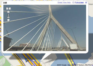
Posted by Andrew Lookingbill, Software EngineerToday we're pleased to announce the launch of 8 new cities with Street View. Check out full spherical views of Boston, Dallas, Fort Worth, Indianapolis, Minneapolis, St. Paul, Detroit, and Providence. Do some sightseeing, and check out views of places like the Zakim bridge in Boston.We're also happy to announce the launch of embeddable panoramas. You can take any Street View panorama visible in Google...
Friday, 7 December 2007

Posted by Aidan Chopra, SketchUp Product EvangelistI've got a quick Santa fix for those of you who are eagerly counting down the days till NORAD tracks Santa's flight.I spent some time modeling jolly ole St. Nick and his reindeer entourage -- and now all we need is a sleigh! I encourage everyone to take a stab at modeling one and uploading it to the 3D Warehouse. I've created a collection in there for yuletide modelers to show off their best work.Check...
Posted by Kat Malinowska, Onion enthusiastThe Onion, one of our favorite news-spoofers, has made available a fantastic layer for Google Earth in tandem with Our Dumb World: Atlas of The Planet Earth, a hilarious new book parodying (you guessed it!) a world atlas. Placemarks across the globe pinpoint lots and lots of geographic features and a whole bunch of important historic sites (read: jokes and more jokes).The Onion has also put together an awesome Google Maps mashup with even more factoids about your favorite lands. Check it out often to...
Thursday, 6 December 2007

Keith Golden, Software Engineer, Google MapsI used to live in Seattle, and I have a lot of friends around there, so all the recent flooding really hits home. Like most people, the first thing I wanted to know was whether my friends were safe and their homes were still intact. I found some great user-created maps that offer more context around what is actually happening on the ground than a few isolated photos or videos from news stories can provide:December...
Wednesday, 5 December 2007

Posted by Wei Luo, Senior GIS SpecialistHere's good news for the international folks: we've just added roads and business listings in a number of countries. We've launched roads for South Africa and Poland, and we've added business listings in six new countries -- Finland, Norway, Denmark, Austria, Sweden and Switzerland. Our Transit layer has also been enhanced with new colors and icons. If you're in one of those countries, launch Google Earth...
Tuesday, 4 December 2007

Posted by Brittany Bohnet, Elections Project ManagerWith the 2008 presidential election just around the corner, political news is continuing to grow more important to U.S. voters. In fact, more than a third of Americans (that's more than 100 million people!) are expected to turn to the Internet for their election information in the coming year.To make accessing this information easier, we have created an elections gadget that will help people stay...
Friday, 30 November 2007
Posted by Melissa Crounse, Santa TrackerFor those of you who have followed Santa's trip in Google Earth for the past few years, you'll be interested to know that this year we've paired up with the real Santa-tracking pros -- the North American Aerospace Defense Command (NORAD).Starting tomorrow, December 1st, you'll be able to count down to the big sleigh ride on the NORAD Tracks Santa website; starting at 1 am PST on December 24th, you'll be able to download a special KML file that lets you follow his trip in real time. Check out the Official...
Posted by Stephen Chau, Product Manager, Google MapsWe've heard from some of you that you're having trouble accessing Street View imagery within the local search and address bubbles, so we're going to work on it a bit more. We're sorry for any disappointment, and we'll keep you posted on our progress. Stay tuned...
Wednesday, 28 November 2007
Posted by Steve Lee, Product Manager, Google Mobile TeamAnyone who's used a GPS-enabled version of Google Maps for mobile knows how useful it can be to have location information. But very few devices actually support GPS, and the technology is still evolving -- it can sometimes take a while to acquire a satellite signal, getting coverage indoors can be difficult, and using GPS can drain your phone's battery. Today Google launched a new version of Google Maps for mobile with a beta technology called My Location, which provides approximate location...
Tuesday, 27 November 2007
Posted by Brian Cornell, Software Engineer, Google MapsIf you use Google Earth, you're probably familiar with the KML and KMZ file formats, which are used to store geographic information like placemarks, lines and shapes. Now you can share your KML files more easily with other people (who may not have Google Earth installed) by importing them into My Maps. Your file will be stored online and will be viewable on any computer with a web browser.To import a KML file, create a new map and click the Import link. You'll be able to upload a file from...
Posted by Jess Lee, Google Maps Product ManagerThe My Maps feature of Google Maps lets people create maps to share their hobbies and expertise with the world. For example, a surfing enthusiast could map out their favorite surf spots or a surfing club could plot all the best beaches in Southern California. Now imagine if all the surfers around the globe worked together, leveraging their combined knowledge to create a single map of the best surf spots worldwide, applying the power of wiki-style collaboration to cartography.Starting today, Google...

Posted by Jie Shao, Software EngineerI'm pleased to announce a whole new method for cruising the streets: Street View via search. In the past, a search of a specific location in Maps yielded a placemark on its location and a pop-up balloon containing its address. Starting today, the balloon will also display a thumbnail preview of the panoramic image for locations where Street View is available. Just click on the thumbnail or the "Street View" link...

Posted by Chris Pennock and Keith Ito, Software Engineers We've noticed that many people build customized maps using My Maps and KML to help others see the planet in a new light. We've seen everything from maps of hiking trails with pictures taken along the way to a guide to the world's mountain peaks. Today we're releasing Terrain maps to help highlight this natural beauty even more. These maps focus on physical features such as mountains, valleys,...
Monday, 26 November 2007
Posted by Steve Miller, Product Manager, Google Earth OutreachWe're so happy (OK, more like ecstatic) about the recent wave of people, companies and organizations "going green." Everywhere you look these days, you see hybrid cars, solar panels, recycling bins, and so on. And we were really thrilled to learn about the U.S. Environmental Protection Agency's new project using Google Earth.The EPA has created an amazing KML file that tracks air emission sources. That means Google Earth users can now track air quality, near and far, from the comfort...
Thursday, 22 November 2007
Posted by Elaine Filadelfo, Thanksgiving Day Parade EnthusiastI'll admit it, I still love the Macy's Thanksgiving Day Parade. In fact, this is the first year in as long as I can remember that I won't be spending my Wednesday evening braving the crowds on 77th Street to see the balloons getting inflated. But I'll definitely be camped out in front of my TV tomorrow morning (with frequent trips to the kitchen to baste my turkey, of course) watching the balloons, floats, and marching bands make their way through Herald Square. Plus, there are...
Monday, 19 November 2007

Posted by Seth LaForge, Software Engineer, Google MapsThe last time I threw a party, I used the My Maps feature of Google Maps to tell my friends exactly how to find my house. But if they'd just searched Maps on their own for my address and had gone to the marker location, they would have been partying in the middle of the street!Now for your next party (or any other occasion), you can move the marker for your address to show the exact entrance of...
Friday, 16 November 2007

Posted by Anna Bishop, Google Earth Education CoordinatorRounding out our celebration of Geography Awareness Week, I’d like to point you to some Google Earth and Maps educational applications that recently caught my attention:Here in the United States, Tim Hunter of the Advanced Technology Environmental Energy Center (ATEEC) brought together over a dozen educators to develop a virtual field trip that explores political and environmental issues in...
Thursday, 15 November 2007
Posted by Sowmya Subramanian, Engineering Manager, Google MapsIn my time spent combing through all of the amazing customized maps created by our users, I've been pleased to find many maps that illustrate the usefulness of My Maps in a classroom setting. For example, I recently found two great ones that illustrate how tools in the My Maps tab can be used by teachers in two very different subjects: Physics and Literature.For one, check out this cool map created by a Physics teacher who has been teaching his 9th grade students about speed, velocity...
Wednesday, 14 November 2007
Posted by Andrew Connolly, Google Visiting Faculty (University of Washington)Google products can be useful in many classes, but today I want to point out how they can be useful in my favorite high school class: astronomy!When I studied astronomy, the teachers used to bring a gigantic star map to class, point at the stars, and tell us all those great stories about them. I always wanted to see deeper into the sky and know more about it, but I had to wait for the annual trip to the observatory to actually do that, unfortunately. With Sky in Google...

Posted by Ryan Sturgell, Software EngineerA few months ago we added a simple and fun way to interactively modify the directions created by Google Maps. You can drag the endpoints of your route to change where the route starts or stops. You can also drag the route itself to modify how you get to your destination. Perfect, right? Well, almost. Our users have told us that, while they love dragging their routes to use the roads they want, they don't...
Posted by Giorgio Scherl, Product Manager Google Maps, Switzerland Falling in love with Switzerland just got even easier. Those romantic lakeside hotels, world-famous chocolate shops, and winding roads through the Alps can now be discovered using Google Maps for Switzerland. The all-new Maps service, developed right here in Zurich, will help people in Switzerland find and enjoy the businesses and services around them. It also includes easy-to-use driving directions and trip-planning public transport information. We worked with Swiss content providers,...
Posted by Christoph Oehler, Product ManagerWe are very happy to announce the launch of Google Transit trip planner in Europe. For quite some time, Google Maps has featured transit stop icons with helpful information like lines serving a station and next departures for many cities. But now you can plan your entire journey using public transportation! So far we have information for the following places and transport companies:- Traveline South East, UK- SBB, Switzerland (train, ferries and long distance bus coverage)- VBZ, Zurich, Switzerland- Turin,...
Tuesday, 13 November 2007
Posted by Tom Wyman, Market Development ManagerIt's always incredible to witness even the youngest children mastering sophisticated web applications at lightning speed. Not long ago, I was wowed to learn that many children with autism have proven to be particularly adept at creating 3D models using Google SketchUp. Last week on the Official Google SketchUp Blog, we announced the creation of Project Spectrum, a program dedicated to connecting the autistic community with free software and learning materials.Project Spectrum was dreamed up by the...
Subscribe to:
Posts (Atom)


